Hikes in the Serra da Estrela (Manteigas)
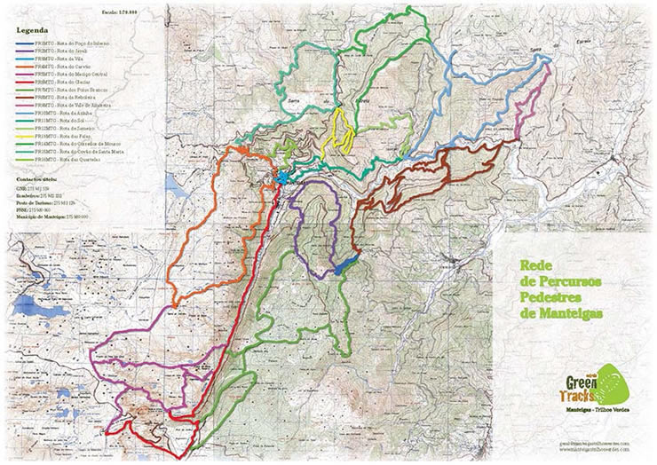
The Organisation "Estrela - Green Tracks" (www.manteigastrilhosverdes.com) organised and marked 16 day hikes in the Manteigas region.
Detailled Description in english including hiking map are available for download below (hikes PR9, PR10, PR12, PR14 only in portuguese language). Every download includes:
- Leaflet with hiking map and description
- Track (in GPX Format)
Overview of all the hikes around Manteigas (For larger view, click on the map).
In the list below of the hike just click on your choice - the description with the track will be downloaded automatically.
Day Hikes Manteigas
| Number WIP | Name | Length | Time |
|---|---|---|---|
| MTG-PR1 | Inferno Well Route | 2.5 km | 1.5h |
| MTG-PR2 | Boar Route | 11 km | 5h |
| MTG-PR3 | Village Route | 1.8 km | 1h |
| MTG-PR4 | Coal Route | 20 km | 8h |
| MTG-PR5 | Central Massive Route | 10 km | 8h |
| MTG-PR6 | Glacier Route | 17 km | 6h |
| MTG-PR7 | Poios Brancos Route | 8 km | 4h |
| MTG-PR8 | Reboleira Route | 15.8 km | 5h |
| MTG-PR9 | Rota de Vale de Amoreira | 5 km | 4h |
| MTG-PR10 | Rota da Azinha | 18.4 km | 6h |
| MTG-PR11 | Sun Route | 4 km | 2.5h |
| MTG-PR12 | Rota de Sameiro | 1.3 km | 1h |
| MTG-PR13 | Beech Route | 5.4 km | 3h |
| MTG-PR14 | Rota de Corredor de Mouros | 15.5 km | 6h |
| MTG-PR15 | Saint Marie Covão Route | 11 km | 5h |
| MTG-PR16 | Quartelas Route | 5.3 km | 3h |

