Home|Accomodation Service|Online Shop| Contact| zur Deutschen Sprache

Hikes in the Serra da Estrela (Seia & Covilhã)

The area around Seia is dominated by the mountain range of Serra da Estrela. Therefore most of the hikes are at altitudes of more then 1000m. Watch out for rapid weather changes at this altitude.


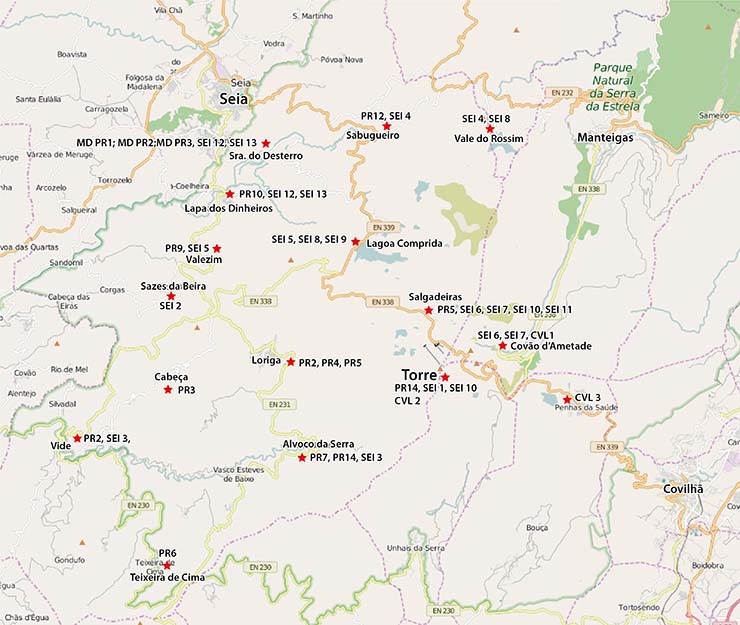
Overview of the Hikes in the Seia Region (for larger picture, click on it):


Costs Map: The maps are free to download. However, we ask for a Donation of 0,50 Euro (or any higher amount!). This allows us to keep our team happy who create and update these maps.

You can donate simply with paypal:


In the list below of the hike just click on your choice - the description with the track will be downloaded automatically.
Day Hikes Seia

NUMBER WIP Name Length Time
CVL 1 Ex-libris Serra da Estrela 12 km 5h
CVL 2 Salgadeiras 13 km 5 h
CVL 3 Na Senda dos Pastores 11 km 5 h
SEI-MD_PR1, PR2, PR3 Mata do Desterro 1.6/6.7/7.5 km 0.75h/2.5h/3h
SEI-PR2 Rota da Ribeira de Loriga 18 km 5h
SEI-PR3 Rota dos Socalcos 2.8 km 1h
SEI-PR4 / PR5 Rota da Eira / Rota da Garganta de Loriga 2.9 / 8.8 km 1h / 3h
SEI-PR6 Rota da Missa 4.2 km 1.5h
SEI-PR7 Rota da Canadas 6.2 km 2h
SEI-PR9 / Sei-2 Rota das Minas do Círio / Rota do Volfâmico 7.1 / 4.2 km 2.5h/2h
SEI-PR10 Rota da Caniça 7 km 2.5h
SEI-PR12 Rota da Fervença 4.7 km 1.5h
SEI-PR14 Rota do Pastoreiro 6.7 km 2.5h
SEI-1 Cantaro Magro 5.7 km 4h
SEI-3 Rota da Ribeira de Alvoco 21.7 km 6h
SEI-4 Rota do Vale do Rossim 8 km 2.5h
SEI-5 Lagoa Comprida - Valezim 8 km 5h
SEI-6 / SEI-7 Covão Cimeiro / Ribeira da Candieira 4.1 / 6 km 3.5h / 5.5h
SEI-8 Lagoa Comprida - Vale do Rossim 9 km 4.5h
SEI-9 Lagoa Comprida 6 km 4h
SEI-10 Torre - Chafariz 6.7 km 4h
SEI-11 Planalto Central 11.5 km 7h
SEI-12 / SEI 13 Ribeira da Canica / Ponte Jugais 8 km 2.5h